Location Map

Nearby Places

Primary Schools

  1. Saint Andrew's Junior School (0.35 km)
  2. Cedar Primary School (0.98 km)
  3. Bendemeer Primary School (1.01 km)
  4. Canossa Catholic Primary School (1.6 km)
  5. St Margaret's Primary School (1.63 km)

Secondary Schools

  1. St Andrew's Secondary School (0.27 km)
  2. Stamford American International School Singapore (0.76 km)
  3. Cedar Girls' Secondary School (0.78 km)
  4. Bendemeer Secondary School (1.09 km)
  5. PlayFACTO School @ Toa Payoh Lor 7 (1.36 km)

MRT Stations

  1. Potong pasir MRT station (0.12 km)
  2. Woodleigh MRT station (0.98 km)
  3. Geylang bahru MRT station (1.11 km)
  4. Boon keng MRT station (1.45 km)
  5. Mattar MRT station (1.74 km)

Nearest Hospitals & Clinics

  1. SATA CommHealth Potong Pasir Medical Centre (0.28 km)
  2. Healthsprings Medical & Laser Clinic (Potong Pasir) (0.55 km)
  3. Vivo Enterprise Pte. Ltd. (0.97 km)
  4. NHGP Toa Payoh Polyclinic (1.1 km)
  5. Kwan Im Thong Hood Cho Temple-NKF Dialysis Centre (1.1 km)

Parks & Recreation

  1. Toa Payoh Sensory Park (1.76 km)
  2. Serangoon Community Park (2.92 km)
  3. 3G Park @ Shunfu (3.85 km)
  4. Bishan North Neighbourhood Park (4.13 km)
  5. Fountain of Wealth (4.13 km)

Supermarkets

  1. Ang Mo Supermarket (0.17 km)
  2. Prime Supermarket (0.51 km)
  3. Giant Supermarket - Kim Keat Avenue (1.21 km)
  4. Prime Supermarket (1.24 km)
  5. Giant Supermarket (1.94 km)

Myra is situated at excellent location and is merely a 2-minute stroll from Potong Pasir MRT along the North-East Line which provides direct rides to Dhoby Ghaut, Chinatown & Harbourfront MRT Interchanges.
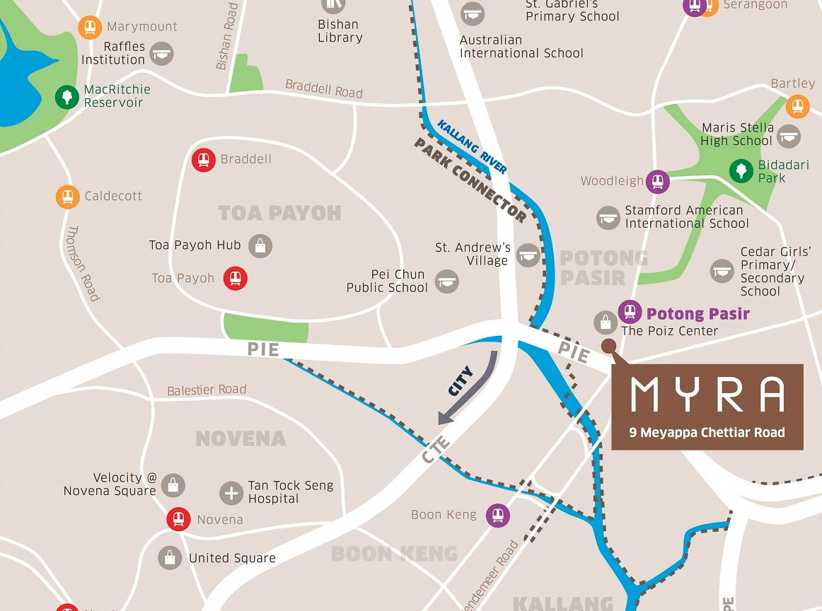
The 3 main expressways namely Central Expressway (CTE), Pan Island Expressway (PIE) and Kallang-Paya Lebar Expressway (KPE) are all accessible from the Myra condo. Myra Alam is one of the closest new developments to the LATAR highway interchange, which will be ready by the time Myra Alam is completed.